|
|
| |
|
 |
|
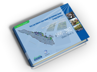
This atlas contains information on the distribution of peatland (7.2 million ha) and below ground carbon content (18.8 22.3 billion tons) in the whole of Sumatera in 1990 and 2002. During those 12 years approximately 354,981 ha of peatland and 3.5 billion tons of carbon (below ground carbon) from Sumateran peatlands were lost. This loss was caused by the conversion of peatland to farmland and plantation, and also by the disastrous peatland and forest fires which occurred recurrently since 1997/98. This reduction in peatland and carbon reserves in Sumatera is not only a great physical loss but also leads to the destruction of other benefits such as flood control, fresh water reserves, prevention of saltwater intrusion, supply of natural resources and support for biodiversity.
The distribution of peatland and carbon content in this book are listed from provincial level to district (kabupaten) level. The province with the largest area of peatland is Riau (4 million ha; mainly in the kabupatens of Indragiri Hilir, Bengkalis, Pelalawan and Rokan Hilir ), followed by South Sumatera (1.4 million ha; mainly in the kabupatens of Ogan Komering Ilir and Musi Banyuasin) and Jambi (700 thousand ha; mainly in the kabupatens of Tanjung Jabung Timur, Batanghari and Tanjung Jabung Barat), the other provinces having from 63,000 to 325,000 ha.
Knowing the distribution of peatland in each kabupaten in Sumatera and being aware of the vital importance of conserving these remaining areas of peatland, it is hoped that the kabupaten and urban governments in Sumatra will be able to utilise this document well as a reference in coordinating development plans in their region. If not, it is feared that mistakes arising from the conversion of peatland to other uses will bring serious disasters upon the community, such as regular fires and floods, difficulties in obtaining fresh water during the dry season, and the loss of the natural biological resources which live in peatland. Moreover, in view of the issue of carbon trade through the Clean Development Mechanisms/CDM within the Climate Change Convention scheme and regulated under the Kyoto protocol, there is a good opportunity for several of Sumateras kabupatens to conserve their peatland and use it for trading carbon by following this mechanism.
|
|
|
|
|
|
|
|
|
|